Information about the two national parks in South Iceland, Þingvellir National park and Vatnajökull National park.
Skálafell – Hjallanes
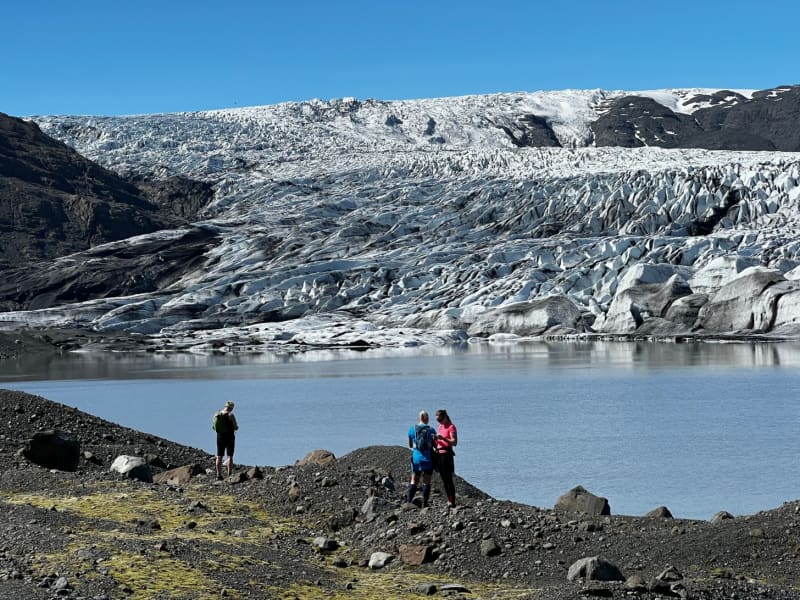
Skálafell is situated in the exact middle between the glacial lagoon Jökulsárlón and the town of Höfn in Hornafjörður. Skálafell offers access to beautiful, marked walking paths around the Hjallanes area within Vatnajökull National Park offering a mere 4 3-4 hrs hike (8 km circle) to the edge of Vatnajökull glacier. Furthermore, a new walkway bridge over the river Kolgríma opens the hiking area of Heinaberg from Skálafell. This area is very popular when it comes to visiting glacial areas.
View
Landmannalaugar - Nature Reserve
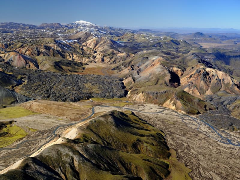
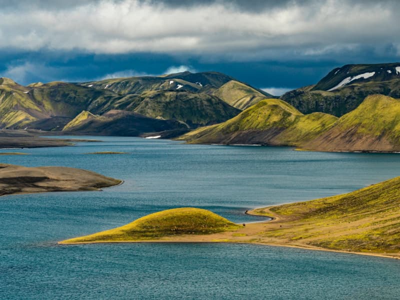
Landmannalaugar derives its name from a hot pool that rises under the Laugahraun lava field. Landmannalaugar has been a stopping point for people for centuries, and the mountain shepherds on Landmannaafréttur have stayed there while herding sheep off the mountain for as long as there have been reports of such travel.
Many beautiful mountains can be seen from Landmannalaugar: Barmur, Bláhnúkur, Brennisteinsalda, Suðurnám, and Norðurnám. The area has considerable deposits of rhyolite, obsidian, and rhyolite lava, and the Landmannalaugar landscape is famous for its colorfulness and unique environs.
The start of one of the most popular hiking trails in Iceland, Laugavegurinn, is at Landmannalaugar. The trail proceeds along Hrafntinnusker, Álftavatn, Hvanngil, and Emstrur and ends in Þórsmörk.
Ferðafélag Íslands (the Iceland Touring Association) provides facilities, such as showers and accommodation, for travelers at Landmannalaugar. In addition, there is a horse rental and a small café operated during the summer.
Fees:The Environmental Agency will implement a booking system for parking in Landmannalaugar for the summer of 2024. It will be necessary to book parking spaces in advance and pay a service fee.
The system will be used from June 20th to September 15th, every day of the week. During this period, all visitors planning to come to Landmannalaugar on their own in a private or rental car between 8 am and 3 pm will need to book a parking space in advance. More information here:
View
Heinaberg
Heinaberg is a beautiful area that consists of Heinabergsjökull glacier, the glacial lagoon Heinabergslón, where you can go kayaking among the icebergs during summer, and stunning landscape. The Heinaberg area is part of Vatnajökull National Park.
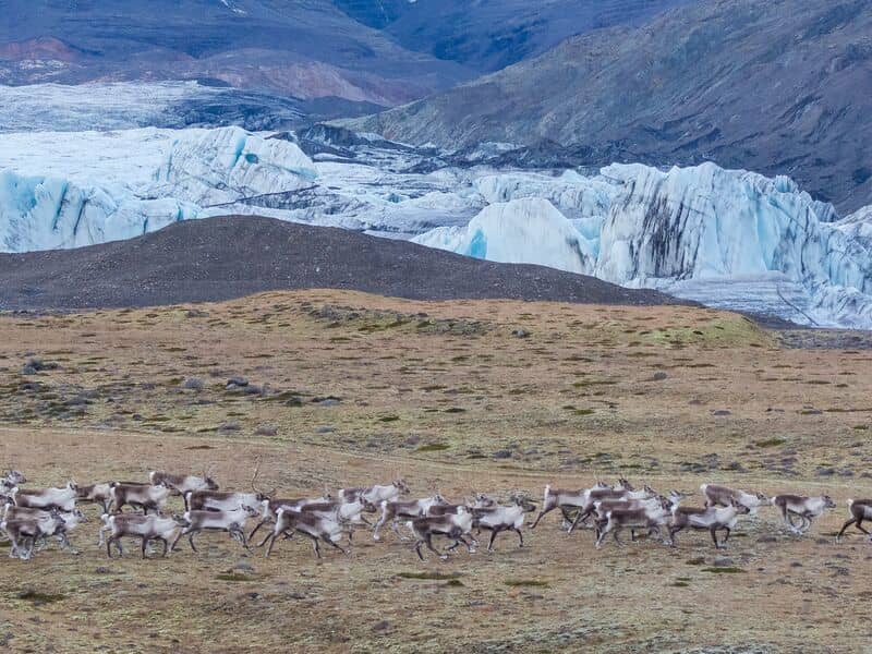
The gorgeous glacial lagoon of Heinaberg, Heinabergslón, is accessible by car and is often studded with large chunks of glacier that break off the Heinabergsjökull glacier. The area offers excellent conditions for hikers, as it has several interesting hiking trails, along which one can see waterfalls, ravines, volcanic intrusions, and even, on a lucky day, a reindeer.
The gravel road from road no 1 to the glacial lake is not in service during the winter months. Therefore, one needs to be aware of changes in road conditions and accessibility.
Vatnajökulsþjóðgarður
View
Lónsöræfi
In Lón District, the most eastern area of the Vatnajökull Region, lie the Stafafellsfjöll mountains, also called Lónsöræfi. They dominate the skyline east of the Vatnajökull glacier and have long comprised one of Iceland’s most extensive protected areas. Besides the deep, rugged canyons, the landscape displays a wide range of colors owing to the presence of rhyolite and other colorful rocks. In contrast, there are also lushly vegetated and sheltered valleys offering a very good chance of spotting reindeer. The numerous hiking trails make this area perfect for hiking. Keep in mind that getting there can be very difficult and one should seek advice from a visitor- or information center before attempting to go there.
View
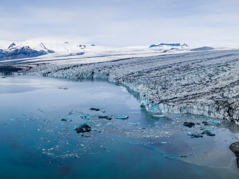
Vatnajökull Glacier
Vatnajökull is the largest glacier in Iceland and the largest glacier by volume in Europe. It covers approx 8 percent of Iceland, measuring an area of 7,700 km² (2021), with an average thickness of 400 m, and the highest point, Hvannadalshnjúkur, measures 2,110 m (6,921 ft.). Vatnajökull has around 30 outlet glaciers flowing from the ice cap, all of which bear a name; glaciers and outlet glaciers all have names that end in "jökull" in Icelandic.
Vatnajökull belongs to the Vatnajökulþjóðgarður (Vatnajökull National Park) and covers a large area surrounding the glacier, including the glacier itself. In 2019, Vatnajökull National Park was inscribed on the UNESCO World Heritage List. The National Park offers numerous exciting sites and is a must for all interested in Geology and beautiful, natural vistas.
View
Vatnajökull National Park
Vatnajökull National Park was established in 2008. It includes the national parks in Skaftafell (est. 1967) and Jökulsárgljúfur (est. 1973) along with the Vatnajökull ice cap itself and extensive areas around it. Today Vatnajökull National Park area covers 15% of Iceland.
A map showing the park’s boundaries (last updated September 21st, 2021): https://www.vatnajokulsthjodgardur.is/static/files/_blob/fuk31dewng5iwwugi4tnkb.jpg
Vatnajökull National Park is characterized by diversity on all fronts, be it landscape, biosphere, cultural remains, or service levels. For simplification, however, it may be placed into two categories: uninhabited highland areas with limited services and lowland areas with higher service levels.
The park‘s visitor centers are all located in lowland areas. Each of them has an exhibition about the park‘s nature and cultural heritage. Each also has a souvenir shop with a special emphasis on local handicrafts and products.
In 2019, Vatnajökull National Park was inscribed upon the UNESCO World Heritage List.
Visitor centres and other tourist information offices working with the parkVisitor centres and other tourist information offices working with the park provide information and services for the park and its immediate environs. The following offices operate along the south coast of Iceland:
• Skaftárstofa Visitor Centre | Kirkjubæjarklaustur | open all year
• Skaftafellsstofa Visitor Centre | Skaftafell | open all year
• Skálafell farm | Suðursveit | varying hours - all year
• Hoffell farm | Nes | varying hours - all year
Vatnajökulsþjóðgarður
View
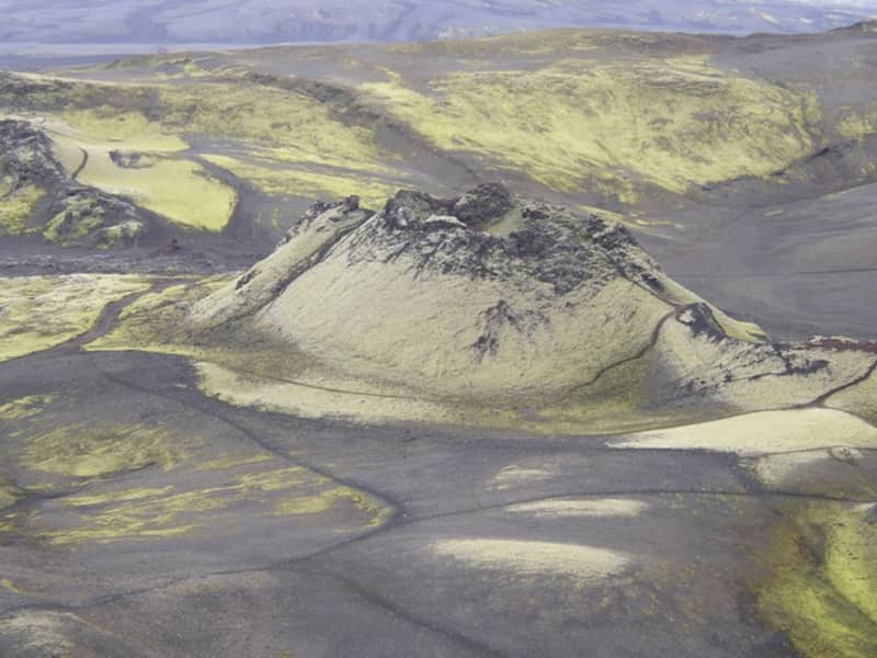
Lakagígar and Laki
Lakagígar is a row of craters formed in one of the world's largest mixed eruptions in recorded history. This continuous series of eruptions emitted a vast quantity of lava and substantial amounts of volcanic ash from a fissure stretching 25 km across the area west of the ice cap. The craters are regarded as a globally unique phenomenon and are, as such, protected within Vatnajökull National Park.
In 1783, a huge lava flow streamed from Lakagígar in what became known as the "Skaftá Fires." This is believed to have been one of the greatest lava flows in a single eruption in the history of the world: the molten lava filled the gorges through which the Skaftá and Hverfisfljót rivers flowed and swept down in two branches into inhabited areas, to spread over the lowlands where it laid waste many farms. The eruption produced large quantities of volcanic ash. For residents of the region and Iceland as a whole, the results of the eruption were catastrophic: this time is known as "Móðuharðindin" (the Haze Famine).
All roads in the western part of the national park are mountain tracks, only navigable for vehicles with four-wheel-drive; some only for large jeeps. Some sections of the road are rocky and full of potholes, and loose gravel is common. It is sometimes necessary to ford (drive through) streams and rivers which can become suddenly swollen, making them difficult, or even impossible, to cross. It is dependent on the weather when the roads are opened. Usually, they are open from early June through to autumn. Driving is only allowed on the roads marked on the accompanying map. All other roads or tracks are closed to the public. Here, as elsewhere in Iceland, driving off-road is banned by law.
View
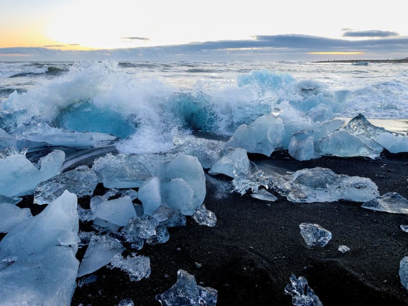
Breiðamerkursandur - Fellsfjara
Next to Jökulsárlón is a less-known attraction within Vatnajökull National Park named -Fellsfjara (Eystri-Fellsfjara on the eastern side of the river and Vestri-Fellsfjara on the western side), which are fields of sand that get strewn with chunks of glacial ice, carried along the river Jökulsá á Breiðamerkursandi, towards the sea and then sent back upon the sands by the tides. The diamond-like pieces of glaciers create a mesmerizing atmosphere in the close mist that often visits the beach. These glistening ice diamonds create an even more spectacular vision in the winter months when the sun comes out and bathes the beach in magical lighting, which reflects off the ice. Waiting around in the darkness for the rising of the sun will be well worth the wait, despite the cold of the Icelandic winter night.
A word of warning: never crawl up on the icebergs and don't choose the ones close to the sea. The photographer must always keep his/her eyes on the sea, or the waves might unexpectedly come in and carry you out to sea.
View
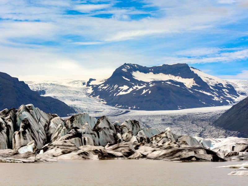
Fjallsárlón Glacial Lagoon
Scenic Fjallsárlón is a glacial lagoon largely within Vatnajökull National Park located around 10 km. west of Jökulsárlón, at the southern edge of Vatnajökull glacier. With the steep glacier tongue, Fjallsjökull coming down from Vatnajökull and all the way into the lagoon makes it a perfectly peaceful place for photos as well as enjoying the untouched nature. Fjallsárlón also offers boat tours on the lagoon as well as a bistro with fresh and tasty refreshments.
View

Skaftafell
Scenic nature, favorable weather conditions, and a network of hiking trails make Skaftafell in Vatnajökull National Park an ideal destination to enjoy outdoor activities in Icelandic nature. Short and easy trails lead to the waterfall Svartifoss and Skaftafellsjökull glacier. Still, those who want to reach further out Morsárdalur valley and Kristínartindar mountain peaks are perfect in terms of distance and labor. Skaftafell is also the ideal base camp for those who seek to climb Iceland‘s highest mountain peak, Hvannadalshnúkur.
During the summer months, the national park offers interpretive tours with rangers. Ask for information at the desk or check the park´s website.
Private travel companies operate in Skaftafell and offer guided hikes on the nearby glaciers and mountains. Also on offer are sightseeing flights over the Vatnajökull glacier and other renowned attractions.
Vatnajökulsþjóðgarður
View
Eldgjá canyon
Eldgjá is an old tectonic graben reactivated in a massive eruption in 934-940. The Eldgjá vents form a discontinuous 75 km long volcanic fissure extending from the Katla volcano in the west to Vatnajökull in the east. The eruption in 934-940 takes its name from a spectacular 150 m deep and 8 km long chasm called Eldgjá (fire fissure) that occupies the central part of the vent system. Part of the fissure is under the protection of the Vatnajökull National Park. There you can take a walk along the bottom of the fissure and witness the sheer scale of it. An easy hike takes you from the car park (with WC facilities) along the bottom of the fissure to Ófærufoss waterfall. Getting there: you need a 4x4, and the area is only accessible in the summer. Eldgjá is a site of international geological significance. Ófærufoss is a distinctive two-tiered waterfall cascading into the fissure Eldgjá.
Eldgjá is reached by the mountain road Fjallabaksleið nyrðri (F 208), west of Kirkjubæjarklaustur. All roads in the western part of the national park are mountain tracks, only navigable for vehicles with four-wheel-drive; some only for large jeeps. Some sections of the road are rocky and full of potholes, and loose gravel is common. It is sometimes necessary to ford (drive-through) streams and rivers, which can suddenly become swollen, making them difficult or even impossible to cross. It is dependent on the weather when the roads are opened. Usually, they are open from early June through to autumn. Driving is only allowed on the roads marked on the accompanying map. All other roads or tracks are closed to the public. Here, as elsewhere in Iceland, driving off-road is banned by law.
View
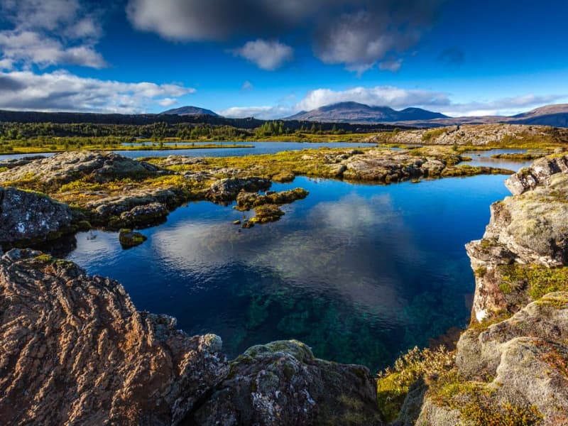
Þingvallavatn Lake
Lake Þingvallavatn lies in a rift valley that extends south from the Langjokull glacier to mount Hengill and from Botnssulur mountains in the west to Lyngdalsheidi heath in the east. The lake is the largest natural lake in Iceland, about 84 square kilometers, at an altitude of approximately 100 meters above sea level. The deepest part of the lake measures 114 meters, which means it reaches below sea level. The catchment area of Lake Thingvallavatn, about 1300 square kilometers, lies in the same direction as the fissure in the area, and its existence is closely connected with its geological history. The water in the lake is very cold and therefore very pure, so snorkeling and diving are popular. Silfra, one of the fissures in the northern part of the lake, is one of the most popular diving spots in Iceland.
View
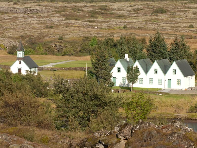
Þingvellir National Park
Þingvellir National Park is a designated UNESCO World Heritage site. It is one of the most important places in Icelandic history, as well as being famous for its unique geological features. It is among the three key locations on The Golden Circle.
The parliament plainsThe site has historical importance spanning over 1000 years. In 930, the Alþingi, one of the oldest parliamentary institutions in the world, was founded. In fact, Þingvellir literally translates to "parliament plains". The Alþingi met annually, and the Lawspeaker recited the law to all the gathered people and resolved disputes as well. This is where Christianity was made the official religion of Iceland around the year 1000. On June 17th, 1944, the independence of The Republic of Iceland was proclaimed in Þingvellir.Where Eurasia meets North AmericaÞingvellir has been a national park since 1928 because of its special tectonic and volcanic environment. The effect of the continental drift can be clearly seen in the cracks and faults traversing the region, the most famous one, Almannagjá, being a veritable canyon.
By Iceland's largest lakeÞingvellir is situated on the northern shore of Þingvallavatn, the biggest lake in Iceland. The river Öxará traverses the national park and forms a waterfall at the Almannagjá called Öxaráfoss. Together with Gullfoss waterfall and the Geysir hot spring area, Þingvellir is part of the famous Golden Circle travel route.
What to seeThe national park contains several points of interest, including Almannagjá Gorge, which showcases the effects of continental drift; Lögberg cliff, where the assembly of Alþing met; Öxarárfoss waterfall; and Peningagjá, a deep fissure with crystal clear water where visitors like to throw a coin and make a wish. A quaint wooden church stands in a picturesque location, and the national park offers a network of walking paths.
Activities and servicesGuests may opt to enter the park's visitor center and exhibition to learn more about Þingvellir's unique history and nature. Along with varied hiking options, visitors may enjoy bird-watching or angling. Fishing permits can be bought on location. Another popular activity at Þingvellir is snorkeling or diving with experienced local tour operators.
CampingÞingvellir is ideal for camping. There are several camping grounds at the national park, some of which offer showers and electricity.
View
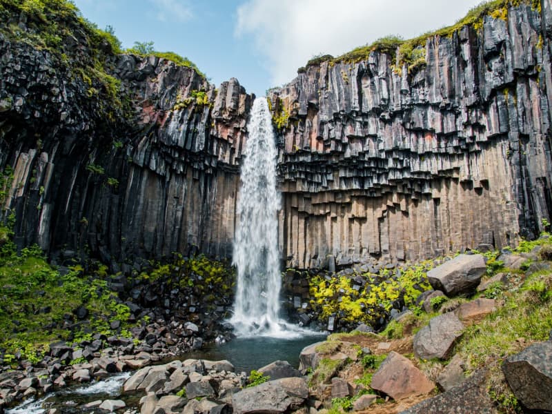
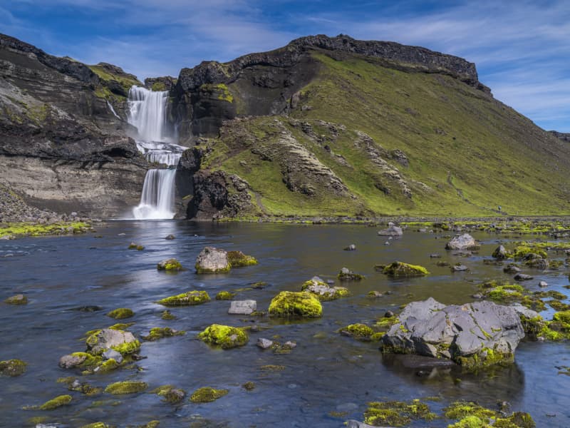
Svartifoss waterfall
Svartifoss is one of the unique waterfalls in South Iceland. It is situated in Skaftafell, which belongs to Vatnajökull National Park. Svartifoss is 20 meters (80ft) high. It is bordered on both sides by tall black basalt columns.
The hike to Svartifoss starts at the Visitor Centre in Skaftafell. You can also find all sorts of information and advice about the area. The hike is about 1.9 km or 45 minutes (one way).
Skaftafell Visitor Centre, Skaftafell
View
Hoffell
Hoffell is a farmland area characterized by a large outlet glacier named Hoffellsjökull and gabbro rock. Gabbro rock originated deep in the earth but is visible in the area due to the uplift of the area and glacial erosion, which gives the environment a greenish hue in the otherwise dark rocks. The Hoffell area is 15 kilometers from the town of Höfn.
Driving or hiking north from Hoffell along the sands of Hoffellssandur, you will enjoy the spectacular scenery of mountain slopes carved out by earlier glaciers. Along the sands of Hoffellssandur, you will enjoy the stunning scenery of mountain slopes carved out by earlier glaciers. Along the way, a borehole is also constructed to extract geothermal water. Finally, you reach the ice of the glacier tongue, Hoffellsjökull, skirted by the numerous hiking trails of the Geitafell mountain.
The area is partly within Vatnajökull National Park, preserved for outdoor recreation and is rich in vegetation, wildlife, and geological variety. The area’s many hiking trails offer a stunning view of the diverse, beautiful wonders it has to offer.
View
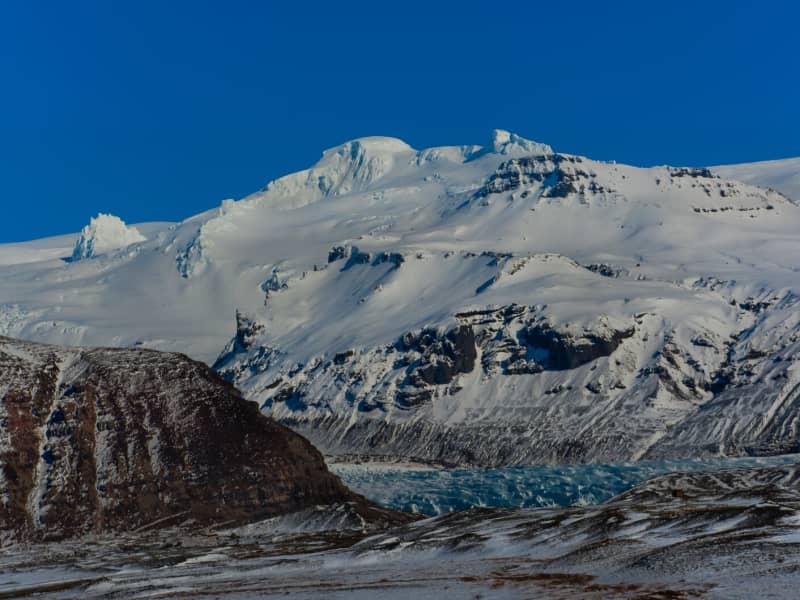
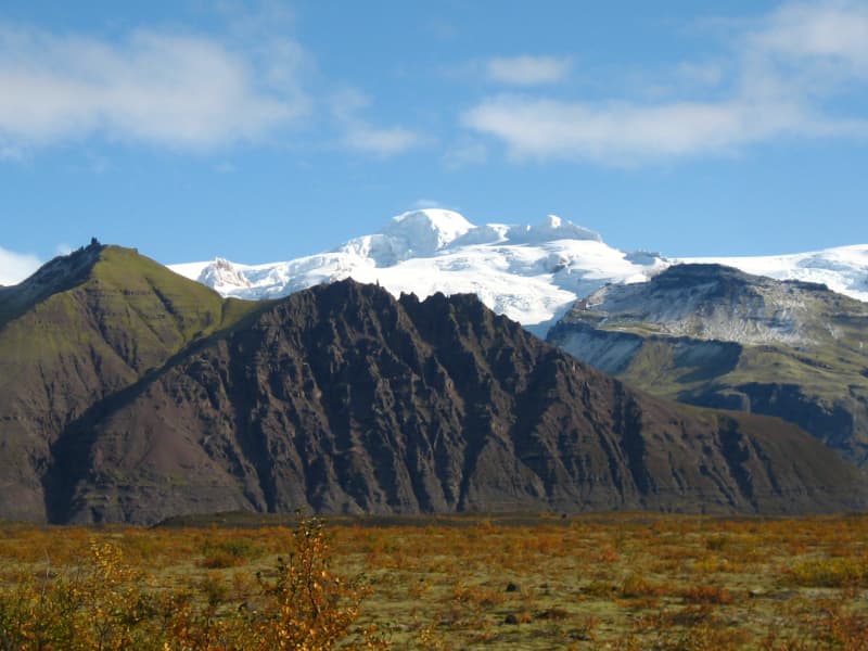
Öræfajökull glacier
Öræfajökull: Iceland’s highest mountainExtending south from the Vatnajökull icecap within Vatnajökull National Park and towering to around 2,110 m (6,922 feet), Öræfajökull is Iceland’s highest mountain. Its height actually varies with the season and the depth of snow and ice, since the peak itself, Hvannadalshnjúkur, is topped by ice which is thickest in spring and thinnest in autumn.
The mountain and surrounding areas offer good skiing in winter and are very popular with walkers and hikers throughout the year.
Vatnajökulsþjóðgarður
View
Langisjór Lake, Fögrufjöll, Grænifjallgarður
Langisjór is a lake within Vatnajökull National Park that's 20 km long and 2 km wide in some places. The lake is to the southwest of Vatnajökull, between the mountains Tungnárfjöll and Fögrufjöll, in a beautiful and picturesque landscape. Its square measure is 27 km², it reaches a depth of 75 m, and the water surface is 670 m above s
Langisjór is reached by the mountain road Fjallabaksleið nyrðri (F 208), west of Kirkjubæjarklaustur. All roads in the western part of the national park are mountain tracks, only navigable for vehicles with four-wheel-drive; some only for large jeeps. Some sections of the road are rocky and full of potholes, and loose gravel is common. It is sometimes necessary to ford (drive through) streams and rivers, which can suddenly become swollen, making them difficult or even impossible to cross. It is dependent on the weather when the roads are open. Usually, they are open from early June through to the autumn. Driving is only allowed on the roads marked on the accompanying map. All other roads or tracks are closed to the public. Here, as elsewhere in Iceland, driving off-road is banned by law.
View

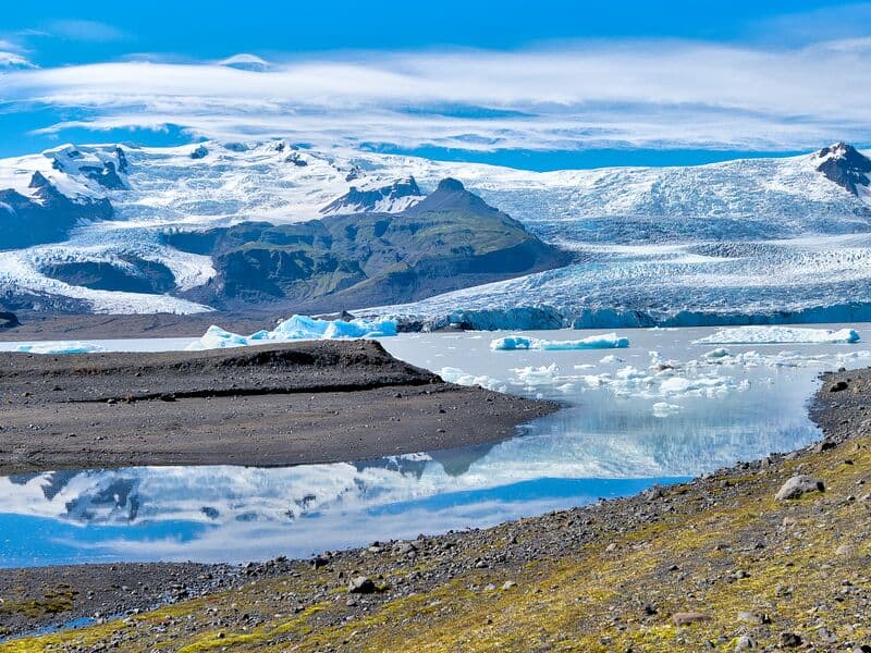
Jökulsárlón Glacier lagoon
Jökulsárlón is a glacial lagoon by the ring road and was recently designated as a part of Vatnajökull National Park. It's still blue waters are a sight not to be missed, as it is dotted with icebergs from the edge of Breiðamerkurjökull, a part of the Vatnajökull glacier. The lagoon flows through a narrow gateway into the Atlantic Ocean, leaving the spectacular sight of the large chunks of ice on the black sandy beach. In wintertime, the fish-filled lagoon hosts a number of seals, which visit the lagoon for an easy meal. Year-round curious seals can be seen basking on the blue-tinted icebergs. The lagoon is accessible from the beach all year round, and so is the café on the banks of Jökulsárlón. For hikers, a marked hiking trail between Jökulsárlón and Fjallsárlón is recommended as a scenic trip through unforgettable surroundings. During the summer, the national park offers interpretive tours with a ranger. Check for information on the park homepage or social media.
A word of warning - don't jump onto the ice floating in the lagoon. Some tourists think it’s okay to do it, but it is dangerous to play, and the ice can capsize, leaving you stuck beneath it in the ice-cold water. So let's be very careful here.
Please heed the advice of the locals and never step on the ice in the lagoon!
Vatnajökulsþjóðgarður
View