Skip to content

Or try searching by Category and/or Location

Sights Along the Ring Road

Geysir Geothermal area
One of the greatest natural attractions of Iceland and part of the famous "Golden Circle Tour," The Great Geysir, or Stori-Geysir, has been dormant since 1916 when it suddenly ceased to spout. It came to life only once in 1935 and quickly went back to sleep. Since then, its repose has sporadically been disturbed by the dumping of tons of carbolic soap powder into its seething orifice to tickle it to spout.  It is not exactly known when Geysir was created. It is believed that it came into existence around the end of the 13th century when a series of strong earthquakes, accompanied by a devastating eruption of Mt. Hekla, hit Haukadalur. In this geothermal valley, Geysir is located. What is known is that it regularly spouted every third hour or so up to the beginning of the 19th century and, after that, progressively at much longer intervals until it completely stopped in 1916. Whether its silence is eternal or temporary, no one knows.  When it was alive and shooting, it could thunderously blast a spectacular jet of superheated water and steam into the air as high as 60 to 80 meters, according to different sources. Its opening is 18 meters wide and its chamber 20 meters deep. One reason for cessation is believed to be the accumulated rocks and foreign objects thrown into it by thousands of tourists throughout the years. Though definitely damaging, this could not be the only reason for its dormancy.  The Great Geysir was among the most notable geysers in the world, such as those in Yellowstone Park, New Zealand, and North Iceland. The English word "geyser" is derived from the Icelandic word "geysir," which means gusher. Though the Great Geysir itself is now more or less inactive, the area surrounding it is geothermically very active with many smaller hot springs.  
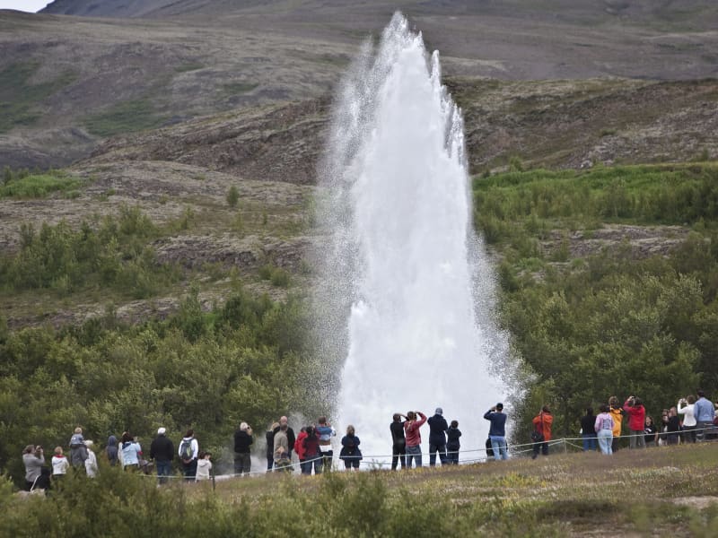
The attraction of the area is now Strokkur (The Churn), another geyser 100 meters south of the Great Geysir, which erupts at regular intervals every 10 minutes or so, and its white column of boiling water can reach as high as 30 meters. The whole area is a geothermal park sitting on top of a vast boiling cauldron. Belching sulfurous mud pots of unusual colors, hissing steam vents, hot and cold springs, warm streams, and primitive plants can all be found here.  A short distance away to the west stands the small Laugarfjall Mountain with a panoramic view overlooking the Geysir area. King Christian IX of Denmark visited the area in 1874 and by the foot of the mountain are the rocks where he leaned while his hosts tried to impress and amuse him by boiling eggs in the hot springs. The rocks are now called Konungssteinar ("The King's Stones").
Gullfoss waterfall
Gullfoss is two separate waterfalls; the upper one has a drop of 11 meters and the lower one 21 meters. The rock of the river bed was formed during an interglacial period. Water flows over Gullfoss at an average rate of 109 cubic meters per second. The heaviest floods have recorded a flow of 2000 cubic meters per second. During the summer, the flow is 130 cubic meters per second, which would take only 3 seconds to fill this building. People were eager to exploit the power potential of Gullfoss, and many plans for hydroelectric developments on the river Hvítá have been proposed. The trails by Gullfoss can be closed, so it's good to check the conditions before going. To check whether it is open or closed to visitors, check out the website of Safetravel.is.  
Þingvellir National Park
Þingvellir National Park is a designated UNESCO World Heritage site. It is one of the most important places in Icelandic history, as well as being famous for its unique geological features. It is among the three key locations on The Golden Circle.  The parliament plainsThe site has historical importance spanning over 1000 years. In 930, the Alþingi, one of the oldest parliamentary institutions in the world, was founded. In fact, Þingvellir literally translates to "parliament plains". The Alþingi met annually, and the Lawspeaker recited the law to all the gathered people and resolved disputes as well. This is where Christianity was made the official religion of Iceland around the year 1000. On June 17th, 1944, the independence of The Republic of Iceland was proclaimed in Þingvellir.Where Eurasia meets North AmericaÞingvellir has been a national park since 1928 because of its special tectonic and volcanic environment. The effect of the continental drift can be clearly seen in the cracks and faults traversing the region, the most famous one, Almannagjá, being a veritable canyon. By Iceland's largest lakeÞingvellir is situated on the northern shore of Þingvallavatn, the biggest lake in Iceland. The river Öxará traverses the national park and forms a waterfall at the Almannagjá called Öxaráfoss. Together with Gullfoss waterfall and the Geysir hot spring area, Þingvellir is part of the famous Golden Circle travel route. What to seeThe national park contains several points of interest, including Almannagjá Gorge, which showcases the effects of continental drift; Lögberg cliff, where the assembly of Alþing met; Öxarárfoss waterfall; and Peningagjá, a deep fissure with crystal clear water where visitors like to throw a coin and make a wish. A quaint wooden church stands in a picturesque location, and the national park offers a network of walking paths. Activities and servicesGuests may opt to enter the park's visitor center and exhibition to learn more about Þingvellir's unique history and nature. Along with varied hiking options, visitors may enjoy bird-watching or angling. Fishing permits can be bought on location. Another popular activity at Þingvellir is snorkeling or diving with experienced local tour operators. CampingÞingvellir is ideal for camping. There are several camping grounds at the national park, some of which offer showers and electricity.
Urridafoss Waterfall
Urriðafoss is a waterfall in the Þjórsá River. Þjórsá is Iceland's longest river, 230 km, and Urriðafoss is the most voluminous waterfall in the country. This mighty river drops down (360 m3/sec) by the edge of the Þjórsárhraun lava field in beautiful and serene surroundings. Þjórsárhraun lava field is the result of the greatest lava flow on earth since the Ice Age. It is located right off highway 1. 
Seljalandsfoss waterfall
A unique waterfall in the river Seljalandsá, about 30 km west of Skógar: it is 60 meters high with a footpath behind it at the bottom of the cliff, but with a thin cascade. It is the only known waterfall of its kind where it is possible to walk behind it. The waterfall is very picturesque; therefore, its photo can be found in many books and calendars. Access to the waterfall is from the farm of Seljaland along the Ring Road, Iceland's main highway. Several falls a little further to the west, including the interesting Gljúfrabúi, partially masked by its canyon. Access to it is from Hamragarðar farm along the road, east of Markarfljót. These "do-not-miss" attractions lie very close to the main Ring Road at the base of the Eyjafjallajökull Glacier, on the road leading into Thorsmörk. During winter, the area around Seljalandsfoss waterfall can be dangerous as paths can be slippery and large pieces of ice fall, making it extremely dangerous to venture too close to the cliffs and particularly dangerous to walk behind the waterfall. The fine mist from the waterfall freezes on the cliffs and the ceiling of the path behind the waterfall, but when the weather warms, and the ice begins to thaw, it can fall off in large chunks, which can be dangerous. People are advised to show caution and respect the closure of the paths. More information can be found on www.safetravel.is  
Skógafoss - Waterfall
Only a few kilometers away from the south shores of Iceland lies the village of Skógar along the Southern Ring Road. It is a popular summer resort center surrounded by unusual scenic beauty. The breathtaking view of Skogáfoss waterfall and picturesque surroundings and the snow-capped heights of two towering glaciers are Skógar's major summer attractions. There are two settlements by this name. One is Ytri-Skógar (outer or western Skógar) and the other Eystri-Skógar (eastern Skógar), located at a short distance from each other. Ytri-Skógar, commonly referred to as Skógar, is the main settlement. It is an old farm and has a church from 1890. It is located between the Skógá and Kverná rivers. The greatest attraction of Skógar is, of course, the beautiful 60-meter high Skogáfoss waterfall in the river Skógá. Like the legends of buried treasures of Egill Skallagrímsson in Mosfell near Reykjavík and Ketilbjörn in Mosfell near Skálholt, there is a similar legend about the settler Þrasi who is believed to have buried his chest of gold under the Skogáfoss waterfall. If the sun conditions are favorable - one can see a vivid rainbow in front of the waterfalls. The river below the falls holds a large salmon and char population, and fishermen are seen here fishing from July - October. The path leading to the top of the waterfalls continues following the river upstream - where numerous more dramatic waterfalls of sheer beauty are found. A great hike - to say the least! One of the finest folk museums in Iceland is situated in extraordinarily beautiful natural surroundings. The fascinating local folk museum has a collection of over 6000 artifacts and examples of various types of dwellings in Iceland since the early times. The collection of tools and equipment used on land and sea is outstanding. The museum also has an old turf farmhouse, where guests can experience the standards of living in Iceland in past centuries. From Skógar, the Ring Road runs eastwards along the foot of Mýrdalsjökull glacier, across the southern sandy plains and over glacial rivers, passes Seljavellir, and continues along with the soaring glaciated massive of Eyjafjöll and the two waterfalls Seljalandsfoss and Gljúfrabúi. From here runs a 10 km long trek along the river Skógá over the Fimmvörðuháls Pass between the Eyjafjallajökull and Mýrdalsjökull glaciers to the mountain oasis of Þórsmörk. Skógar is a place to explore the natural diversity of the south or, if the weather is good, to spend a holiday amid beautiful and rugged landscapes. It is also very close to the ocean and the unique black beach.
Reynisfjara, Reynisfjall og Reynisdrangar
Reynisfjall is a 340 m high tuff mountain arising out of a volcanic eruption from under a glacier in the penultimate Ice Age, near the village of Vik.  Alternating in an irregular manner are layers of tuff, pillow lava and columnar basalt veins and loops.  Reynisdrangar stacks are a collection of 66 m high rock pillars that rise out of the sea and are of the same geological formation as Reynisfjall. On Reynisfjöru beach, very beautiful basalt formations in the south part of the mountain can be seen, and there you will find an exceedingly beautiful cave called Hálsanefshellir.  The waves here are deceiving and have caused the death of a number of visitors in recent years, even in the best of weather. Please take great care and keep a good distance from the sea.
Skaftafell
Scenic nature, favorable weather conditions, and a network of hiking trails make Skaftafell in Vatnajökull National Park an ideal destination to enjoy outdoor activities in Icelandic nature. Short and easy trails lead to the waterfall Svartifoss and Skaftafellsjökull glacier. Still, those who want to reach further out Morsárdalur valley and Kristínartindar mountain peaks are perfect in terms of distance and labor. Skaftafell is also the ideal base camp for those who seek to climb Iceland‘s highest mountain peak, Hvannadalshnúkur. During the summer months, the national park offers interpretive tours with rangers. Ask for information at the desk or check the park´s website. Private travel companies operate in Skaftafell and offer guided hikes on the nearby glaciers and mountains. Also on offer are sightseeing flights over the Vatnajökull glacier and other renowned attractions. Vatnajökulsþjóðgarður 
Fjallsárlón Glacial Lagoon
Scenic Fjallsárlón is a glacial lagoon largely within Vatnajökull National Park located around 10 km. west of Jökulsárlón, at the southern edge of Vatnajökull glacier. With the steep glacier tongue, Fjallsjökull coming down from Vatnajökull and all the way into the lagoon makes it a perfectly peaceful place for photos as well as enjoying the untouched nature. Fjallsárlón also offers boat tours on the lagoon as well as a bistro with fresh and tasty refreshments. 
Jökulsárlón Glacier lagoon
Jökulsárlón is a glacial lagoon by the ring road and was recently designated as a part of Vatnajökull National Park. It's still blue waters are a sight not to be missed, as it is dotted with icebergs from the edge of Breiðamerkurjökull, a part of the Vatnajökull glacier. The lagoon flows through a narrow gateway into the Atlantic Ocean, leaving the spectacular sight of the large chunks of ice on the black sandy beach. In wintertime, the fish-filled lagoon hosts a number of seals, which visit the lagoon for an easy meal. Year-round curious seals can be seen basking on the blue-tinted icebergs. The lagoon is accessible from the beach all year round, and so is the café on the banks of Jökulsárlón. For hikers, a marked hiking trail between Jökulsárlón and Fjallsárlón is recommended as a scenic trip through unforgettable surroundings. During the summer, the national park offers interpretive tours with a ranger. Check for information on the park homepage or social media. A word of warning - don't jump onto the ice floating in the lagoon. Some tourists think it’s okay to do it, but it is dangerous to play, and the ice can capsize, leaving you stuck beneath it in the ice-cold water. So let's be very careful here. Please heed the advice of the locals and never step on the ice in the lagoon!   Vatnajökulsþjóðgarður 
Haukafell
Haukafell is a forestry project that was launched in 1985 and now offers ample shelter to the low-lying, local vegetation, which mostly consists of berry bushes that are ripe for picking in August. The area is situated east of Fláajökull glacier and is a popular outdoor area for the locals. There are various hiking trails to be enjoyed in the beautiful surroundings and the crispy fresh air. From Haukafell you find a marked hiking trail to Fláajökull glacier, where you cross a recent walkway over the Kolgrafardalsá river. In Haukafell you find a good campsite in a beautiful area. 
Hoffell
Hoffell is a farmland area characterized by a large outlet glacier named Hoffellsjökull and gabbro rock. Gabbro rock originated deep in the earth but is visible in the area due to the uplift of the area and glacial erosion, which gives the environment a greenish hue in the otherwise dark rocks. The Hoffell area is 15 kilometers from the town of Höfn. Driving or hiking north from Hoffell along the sands of Hoffellssandur, you will enjoy the spectacular scenery of mountain slopes carved out by earlier glaciers. Along the sands of Hoffellssandur, you will enjoy the stunning scenery of mountain slopes carved out by earlier glaciers. Along the way, a borehole is also constructed to extract geothermal water. Finally, you reach the ice of the glacier tongue, Hoffellsjökull, skirted by the numerous hiking trails of the Geitafell mountain. The area is partly within Vatnajökull National Park, preserved for outdoor recreation and is rich in vegetation, wildlife, and geological variety. The area’s many hiking trails offer a stunning view of the diverse, beautiful wonders it has to offer.  
Vestrahorn
In Iceland, one of the first settlement farms was Horn, built by Hrollaugur, son of Rögnvaldur Earl of Møre in Norway. The Hornafjörður Municipality and several natural sites are named after the settlement farm. Horn means the same thing in Icelandic and English.  The area is approximately a ten-minute drive away from Höfn. The Horn area is below Vestra-Horn, a 454-meter-high mountain, and it is an interesting geological site composed of un-stratified plutonic rock, mostly gabbro but with some granophyre. East of the mountain is a strange-shaped outcrop called Brunnhorn that stretches out to sea. Seals also tend to hang out on the stretch of sand, so if you’re lucky, you can also catch a picture of a lazing seal.  During the Second World War, the Horn area became a base for the British army, and later a NATO radar station was set up at Stokksnes, south of Horn. At Stokksnes, you can feel the power of the Atlantic Ocean as the waves hit the rocky shore with massive force.  
Almannaskarð
Almannaskarð is an old mountain road about 10 km to the east of Höfn. Today the southwest ramp is closed for car traffic, as in 2005 it was replaced by a 1300 m long tunnel that curves under a mountain. Since then the area has become a popular hiking path for locals and at the top of the road is a magnificent viewpoint where you can enjoy a panoramic view of the Hornafjörður region as well as the Vatnajökull glacier, on a clear day. It is a charming stop for those who crave the tranquility and natural beauty of the countryside. 
Lónsöræfi
In Lón District, the most eastern area of the Vatnajökull Region, lie the Stafafellsfjöll mountains, also called Lónsöræfi. They dominate the skyline east of the Vatnajökull glacier and have long comprised one of Iceland’s most extensive protected areas. Besides the deep, rugged canyons, the landscape displays a wide range of colors owing to the presence of rhyolite and other colorful rocks. In contrast, there are also lushly vegetated and sheltered valleys offering a very good chance of spotting reindeer. The numerous hiking trails make this area perfect for hiking. Keep in mind that getting there can be very difficult and one should seek advice from a visitor- or information center before attempting to go there.