Mýrdalsjökull glacier and Katla
Mýrdalsjökull Glacier and Katla Volcano
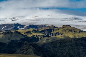
Mýrdalsjökull is a glacier located in the south of Iceland. It is situated to the north of Vík í Mýrdal and the east of the smaller glacier Eyjafjallajökull. Its peak reaches 1493 m in height, and in 1980, it covered an area of 595 km². The view on a clear day is one of the prettiest in the world.
Guided snow scooters, snowmobiles, Super Jeep, and ice-climbing tours are offered on the Myrdalsjökull glacier. Travelers on the glacier must be cautious about crevasses, and inexperienced travelers should not go alone. Weather conditions shift rapidly high winds, and snowstorms can appear in a flash all year round.
The volcano Katla in the Mýrdalsjökull glacier, the volcano Katla erupts on average every 40 - 60 years. Sixteen eruptions have been recorded since the settlement of Iceland, the last in 1918, but there have probably been more. Katla is one of the most famous volcanoes in the country, and its eruptions usually have very serious consequences. It can be regarded as one of the most powerful volcanoes in the world and probably the largest active volcano in the northern hemisphere.
During the eruption, the glacier above the volcanic vent melts, and the melted water collects under the ice cap until it makes its way out under the edge in a violent flood. These are called "jokulhlaup."The floodwater carries huge amounts of ice, rocks, silt, and sand. Most of the Mýrdalssandur sand plain has been formed by deposits in past floods.
Katla has been showing signs of unrest recently, and some geologists suspect it might erupt soon since it is way overdue to erupt.
Eruptions of Katla have taken place (since known and recognized human settlement): 1918, 1860, 1823, 1755-56, 1721, 1660-61, 1625, 1612, 1580, 1416, 1357, 1311, 1262, 1245, 1177, 950.


